


Discover the most scenic parks and recreation areas in Black River Country—where peaceful lakes, wooded landscapes, and family-friendly spaces create the perfect setting to relax and explore.
Whether you’re planning a laid-back afternoon, a family outing, or a quiet moment in nature, these local parks highlight the natural beauty and accessibility that make Black River Falls a standout destination.
Lake Wazee Recreation Area
Wisconsin’s deepest inland lake (355 ft) with incredible water clarity—often reaching 30–40 feet of visibility in summer—makes this one of the most unique recreation areas in the Midwest.
Amenities:
Diving, fishing, hiking, non-motorized boating, swimming, playground, camping, picnic areas
Directions:
Exit #116 → Hwy 54 East → Right on Brockway Road
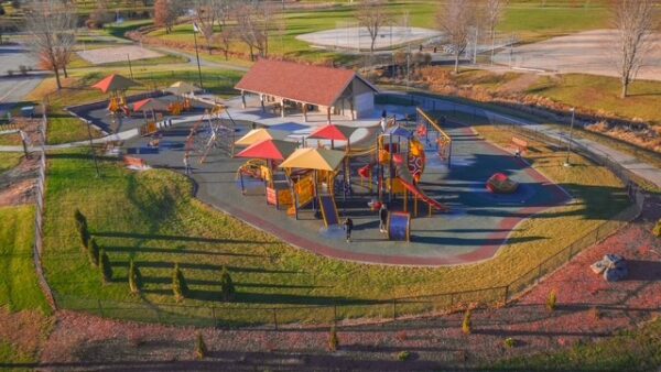
Lunda Community Park – All Abilities Playground
A premier community park designed to be inclusive, accessible, and fun for visitors of all ages and abilities.
Amenities:
Electricity, picnic area, restrooms, skatepark, walking trail, shelters available for rent
Directions:
Exit #116 → Left on WIS-54 → Right on N 10th St → Left on Tyler St
Castle Mound
A unique combination of scenic overlook and modern campground, Castle Mound offers year-round access and a memorable elevated view of the surrounding landscape.
Campground Details:
35 sites (21 non-electric, 14 electric), including ADA-accessible site. Facilities include accessible showers, flush and vault toilets, indoor shelter, dump station, and firewood sales.
Amenities:
Electricity, picnic area, restrooms, cross-country skiing, handicap accessible
Directions:
Exit #116 → ½ mile to Hwy 27 South → Hwy 12 East for 1 mile

Oxbow Pond
A quiet, tucked-away spot ideal for relaxing and enjoying nature. Oxbow Pond is stocked annually with trout, making it a favorite for a peaceful day outdoors.
Amenities:
Fishing, picnic area
Directions:
Exit #116 → Hwy 54 East (7.5 miles) → Left on Cemetery Road (1.5 miles)

Perry Creek
A peaceful natural area featuring a half-mile volunteer-maintained trail along the lower Black River—perfect for those seeking a quiet escape.
Amenities:
Fishing, picnic area
Directions:
Exit #116 → Hwy 54 West → Hwy 27 South (2.8 miles)

Lake Arbutus
Spanning 839 acres, Lake Arbutus is one of the region’s largest recreation lakes, offering expansive views and multiple access points.
Highlights:
3 beaches and 7 boat landings
Amenities:
Fishing, boating, swimming, park areas, camping, picnic areas
Directions:
Exit #115 → Hwy 12/27 North → Turn on Hwy E to Hatfield

Take Time to Enjoy the Outdoors
Each of these parks offers something different—from quiet ponds and wooded trails to expansive lakes and inclusive community spaces. Together, they create a well-rounded outdoor experience that’s easy to explore and even easier to enjoy.
Plan Your Visit
Find maps and visitor resources here:
👉 https://www.blackrivercountry.net/maps-trail-guides/
Why Visit These Parks?
- Scenic, uncrowded outdoor spaces
- Family-friendly and accessible locations
- Easy-to-follow directions from I-94
- A variety of landscapes within minutes of each other
CALL-TO-ACTION
- 🌳 Plan Your Park Day: Choose your destination and head out
- 📍 Explore More Than One: Several parks are within a short drive
- 📸 Bring Your Camera: Incredible photo opportunities at every stop
- 👨👩👧 Make It a Family Trip: Safe, welcoming environments for all